Portal, AZ - Rodeo, NM
Serving The Communities Of Portal and Rodeo (www.portal-rodeo.com)
Serving The Communities Of Portal and Rodeo (www.portal-rodeo.com)

Hiking
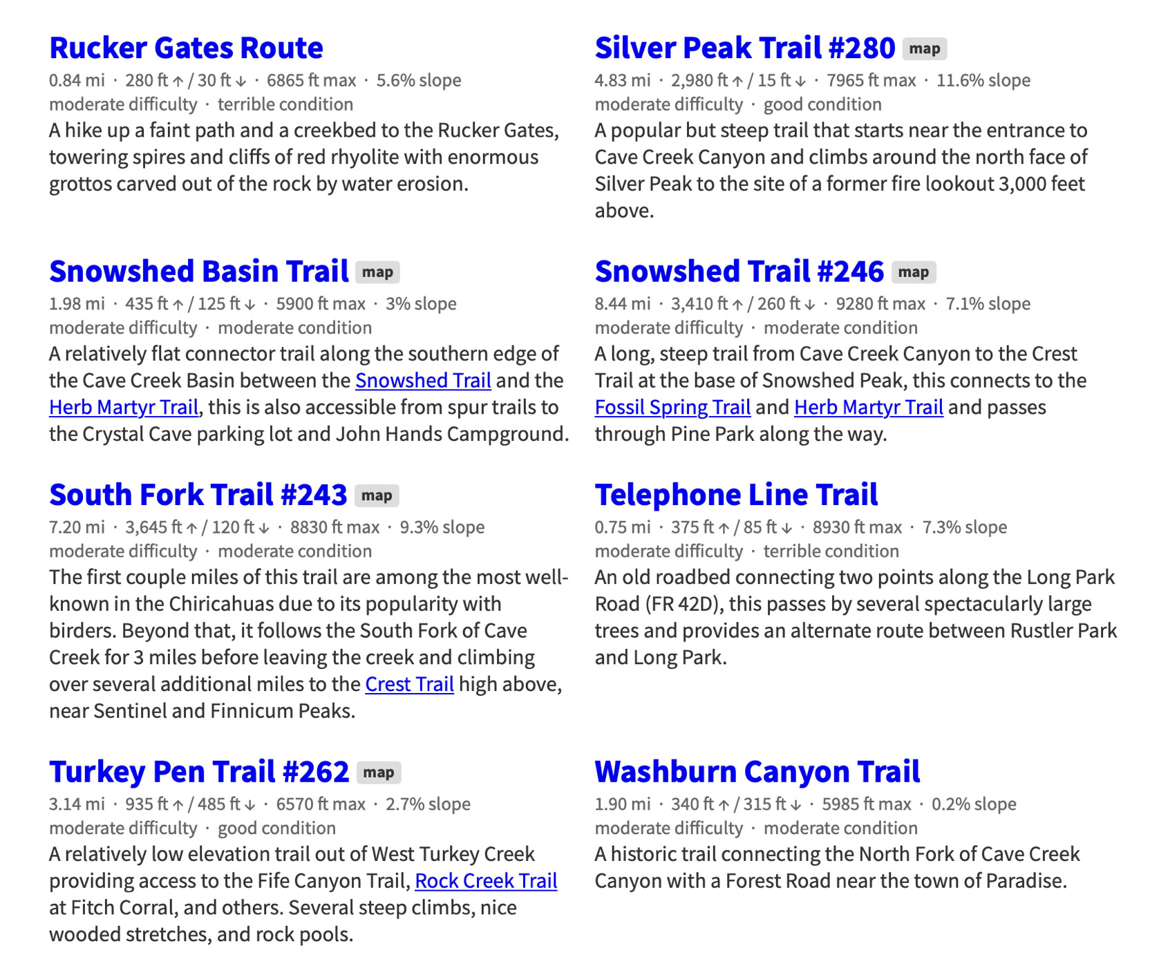
July 16 - Rucker Canyon Trail
Meet at the Rodeo Post Office at 8:00 a.m. AZ, 9:00 a.m. NM
Carol Simon (520) 558-2433 casimon1947@icloud.com
Elaine Moisan (520) 558-5204 emoisan2011@hotmail.com
Elly Van Gelderen (520) 558-3715 or ellyvangelderen@asu.edu
__________________________________________________________________________
Click On Any Image To See It In Its Original (Larger) Size
Hike report, 7/9/26: toward Centella Point
It being early July (i.e. hot) and a good chance of a thunderstorm (according to NWS) only 4 of us gathered for this week's hike. We all could fit into one car and drove to Rustler Park on the deteriorating 42 Road (i.e. Onion Saddle/trans mountain). We advise people to keep their jaws clenched on the 42 Road so their fillings don’t jiggle out.
Rustler Park is lovely: a green meadow with yellow sneezeweed blooming and remnants of the original forest mostly on the south side. We hiked up the Long Park Road this week as our vehicle didn’t have great suspension… and you better have that and good clearance to go there. The morning temperature being cool, we opted for trying the old “Telephone Line Road” (trail) that parallels the USFS route, There were a few down logs but otherwise it was a great side trip. The giant Douglas fir is still doing great, but the huge aspen fell years ago and lies across the drainage. Red-faced warblers fed above us, and Hermit Thrushes were singing. At Long Park we saw Bluebells and Larkspur blooming between the sneezeweed:
The trail to Fly Saddle is getting a little crowded by ferns, but it easy to follow. After a water and raspberry break at the Saddle (5 Points), we took the far left fork out toward Centella Point. The trail has been kept clear by many crews for many years as attested by literally hundreds of sawn logs. Currently it could use a crew of loppers to push back the aspen, willows and raspberries, but it is a beautiful trail. Tub Spring was dry again, but the unnamed spring another 1/2 mile out did have a small pool at the crossing.
Centella Point was our original destination. “Centella” is the Spanish word for “spark” - I’ve been told that the point it is a great spot to experience lightning up close and personal. The clouds were building and thunder rumbled in the distance and none of us were in the mood to repeat Ben Franklin’s experience, so we turned back after lunch.
Back down the trail past Tub Spring looking for the raspberries we missed on the way up…
At Fly Saddle we continued on the Crest Trail toward the north. There are great vistas to the east across the Sulphur Springs Valley and a nice trail almost on the contour to Bootlegger Saddle. Another water break and a short trip to a superb overlook before we headed back towards Rustler. We separated into two groups; one hiked the Crest Trail past the rock cliff and the other hiked the road. There was one couple putting up a tent in the campground they otherwise had to themselves. The NWS rain prediction didn’t come true today.
Next week we will meet at the Rodeo Post Office at 8 AZ, 9 NM. We will drive south towards Douglas and turn onto the Tex Canyon road to get to the Rucker Canyon Trail. The trail is at moderate elevation but being in the canyon bottom with lots of big conifers, we expect the temperature to be reasonable. Last year at least 2 volunteer groups did a tremendous amount of work and opened the trail about 3 miles along the Creek. Additional work got the steep switchbacks cleared to the ridge top. Hikers may not want to climb the switchbacks, but the trail along the Creek is at a low grade, mostly. We will return the way we came. The County dirt road to Rucker is rather long and could get muddy if it ever rains. Should that happen, the hike could be changed when we meet. Remember lunch, hat, water, raincoat and good boots.
Hike report from Al, photos from Elaine


Easy Trails
Moderate Trails
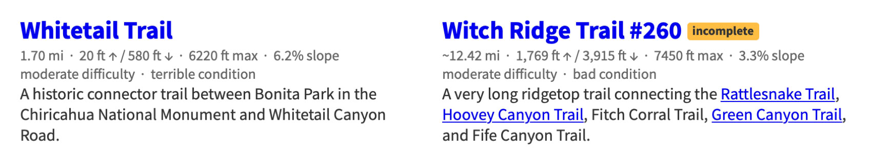
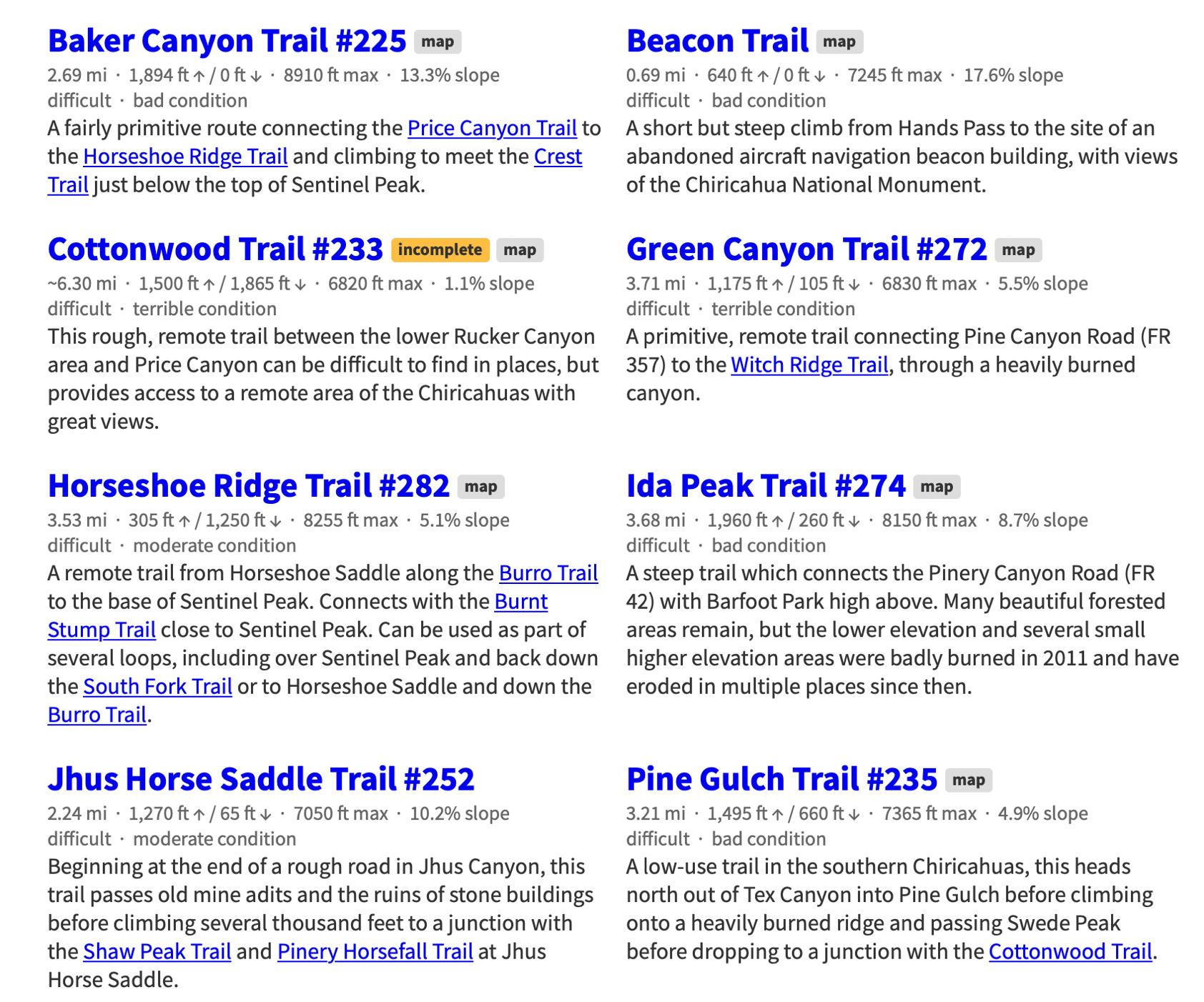
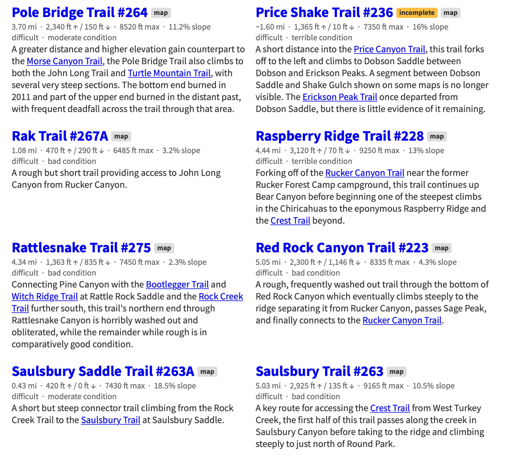
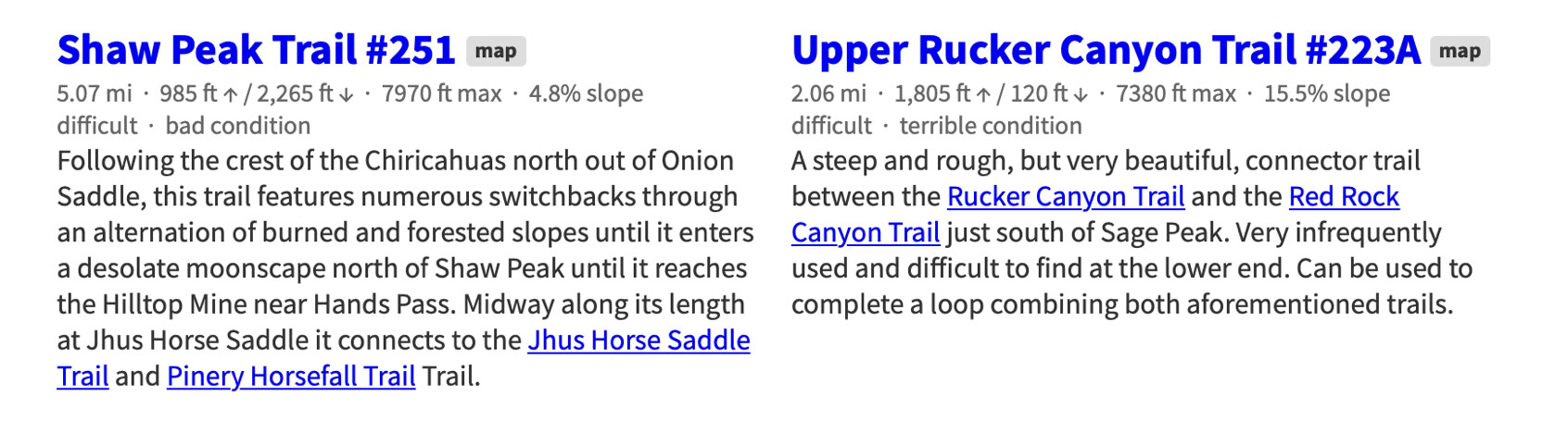
Difficult Trails
Expert Trails
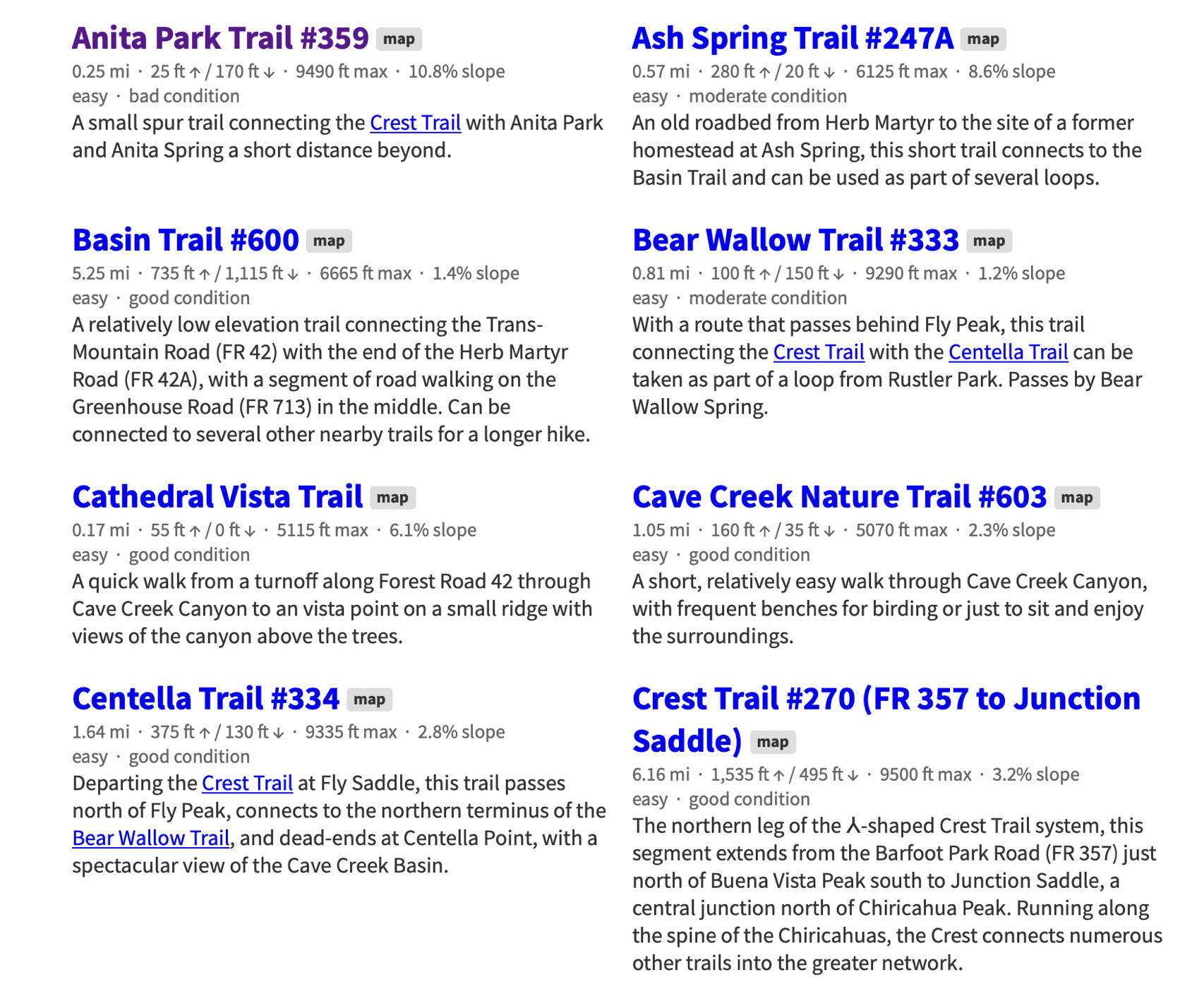
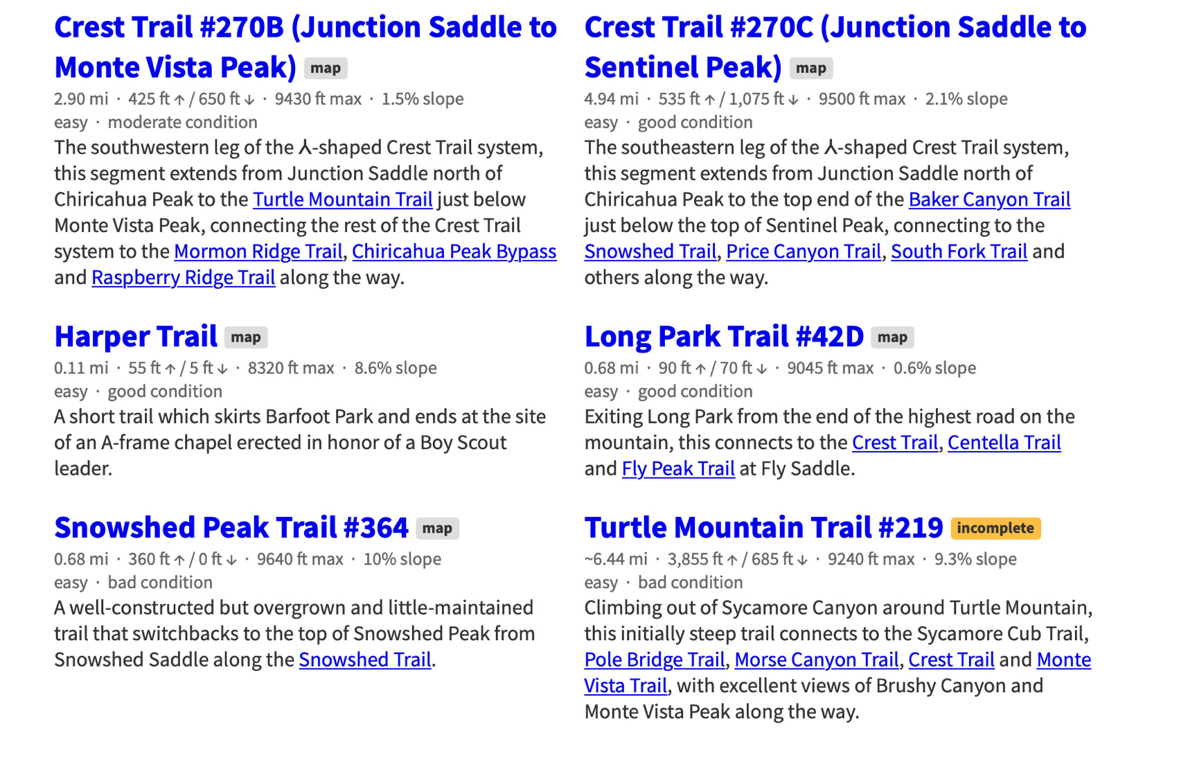
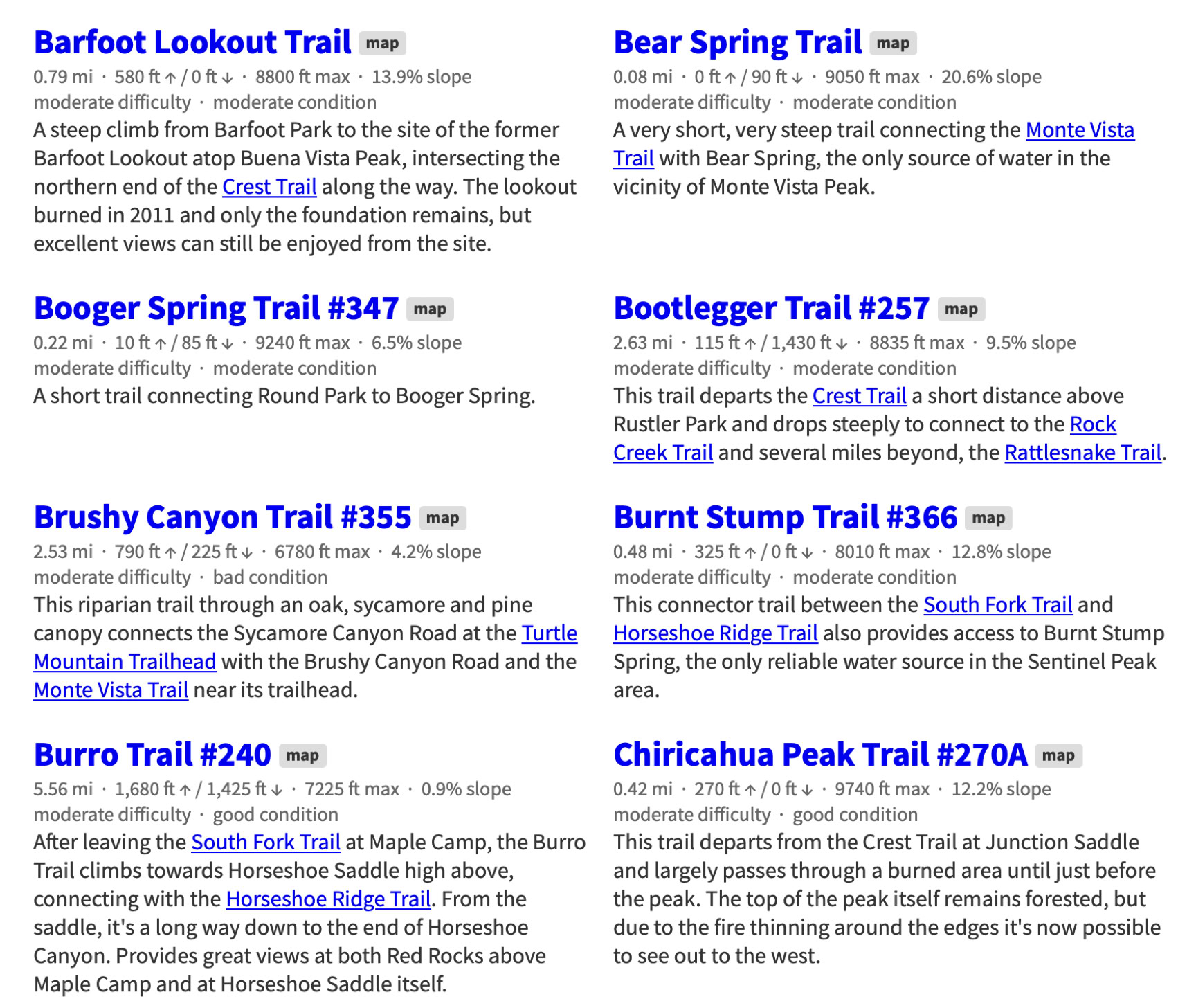
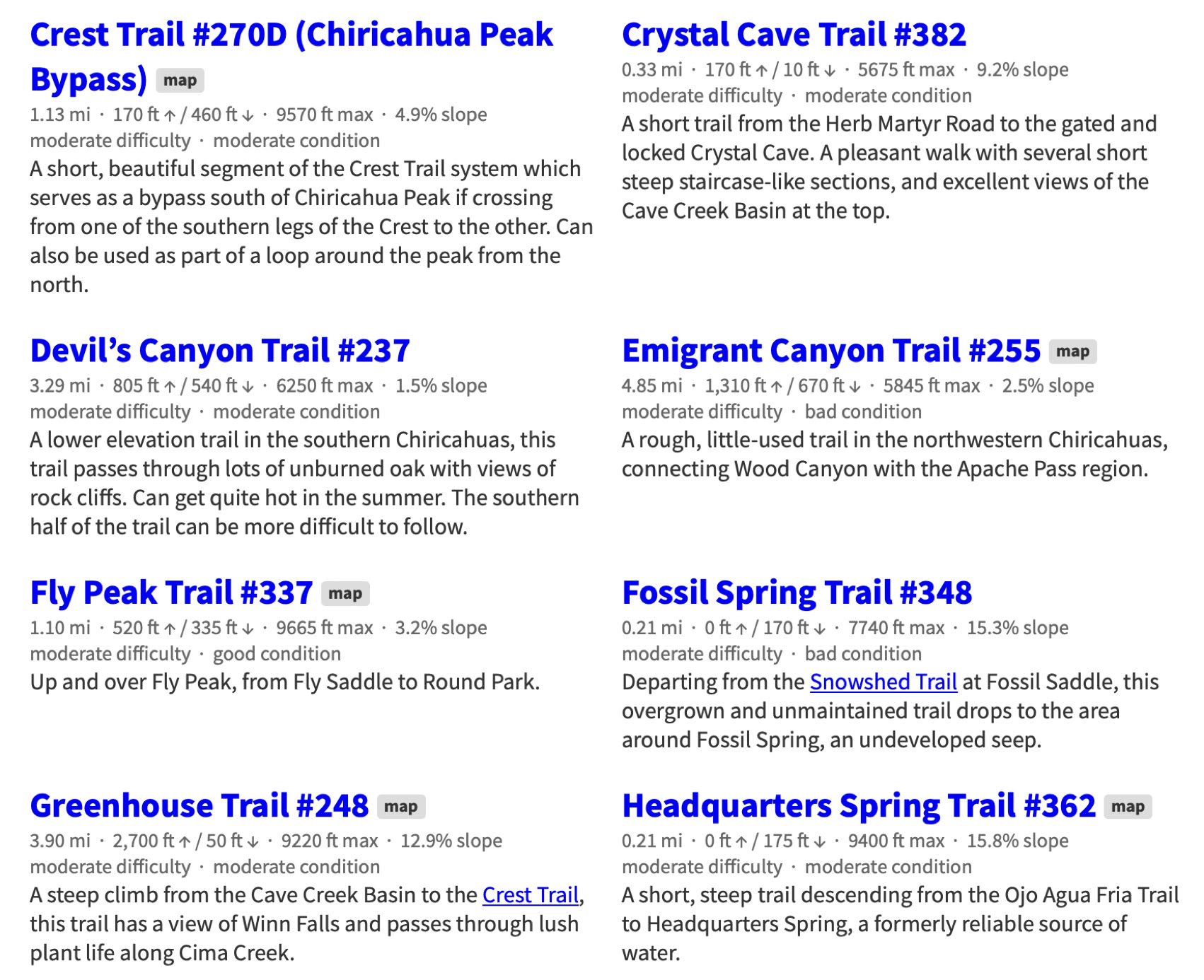
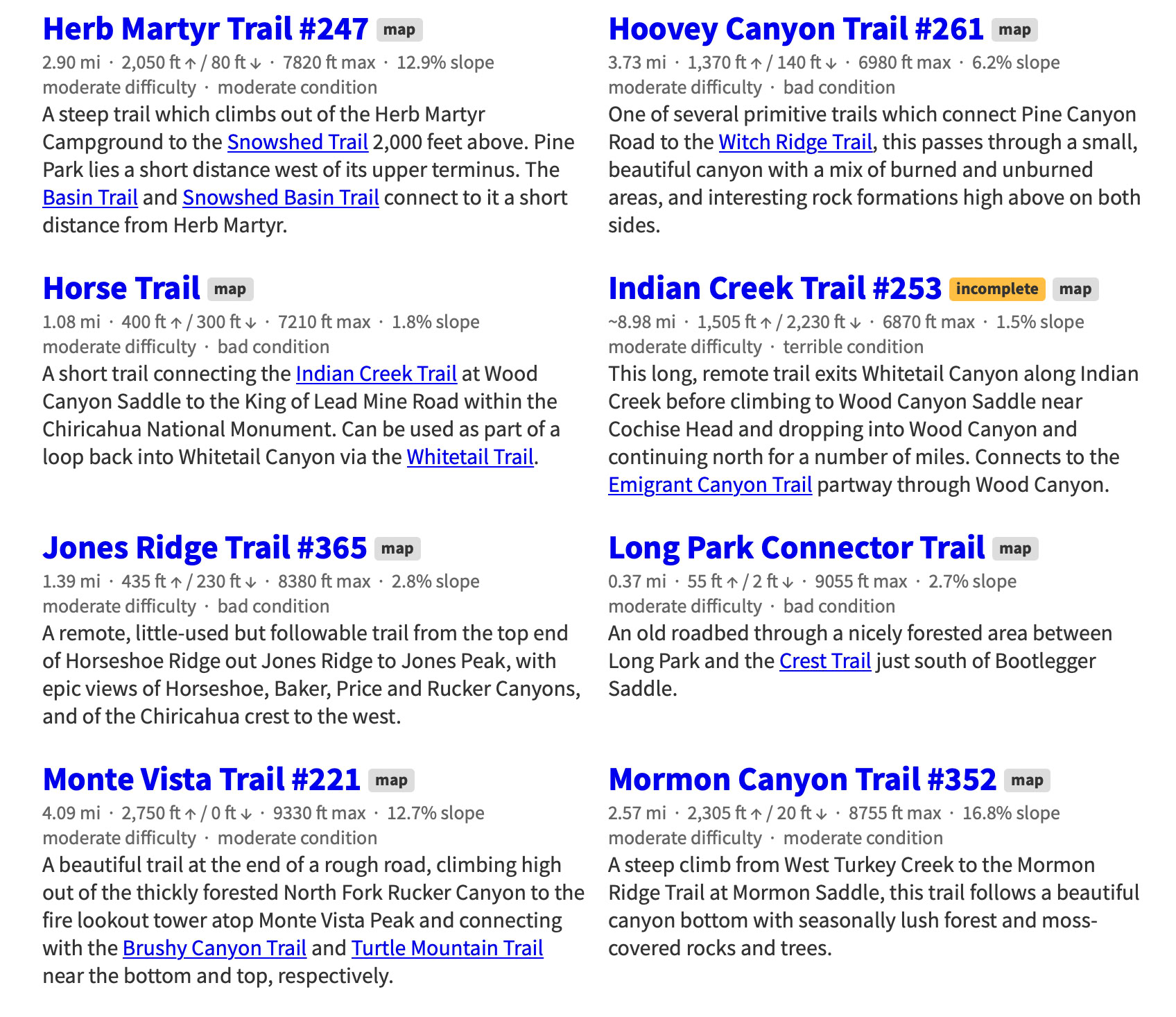
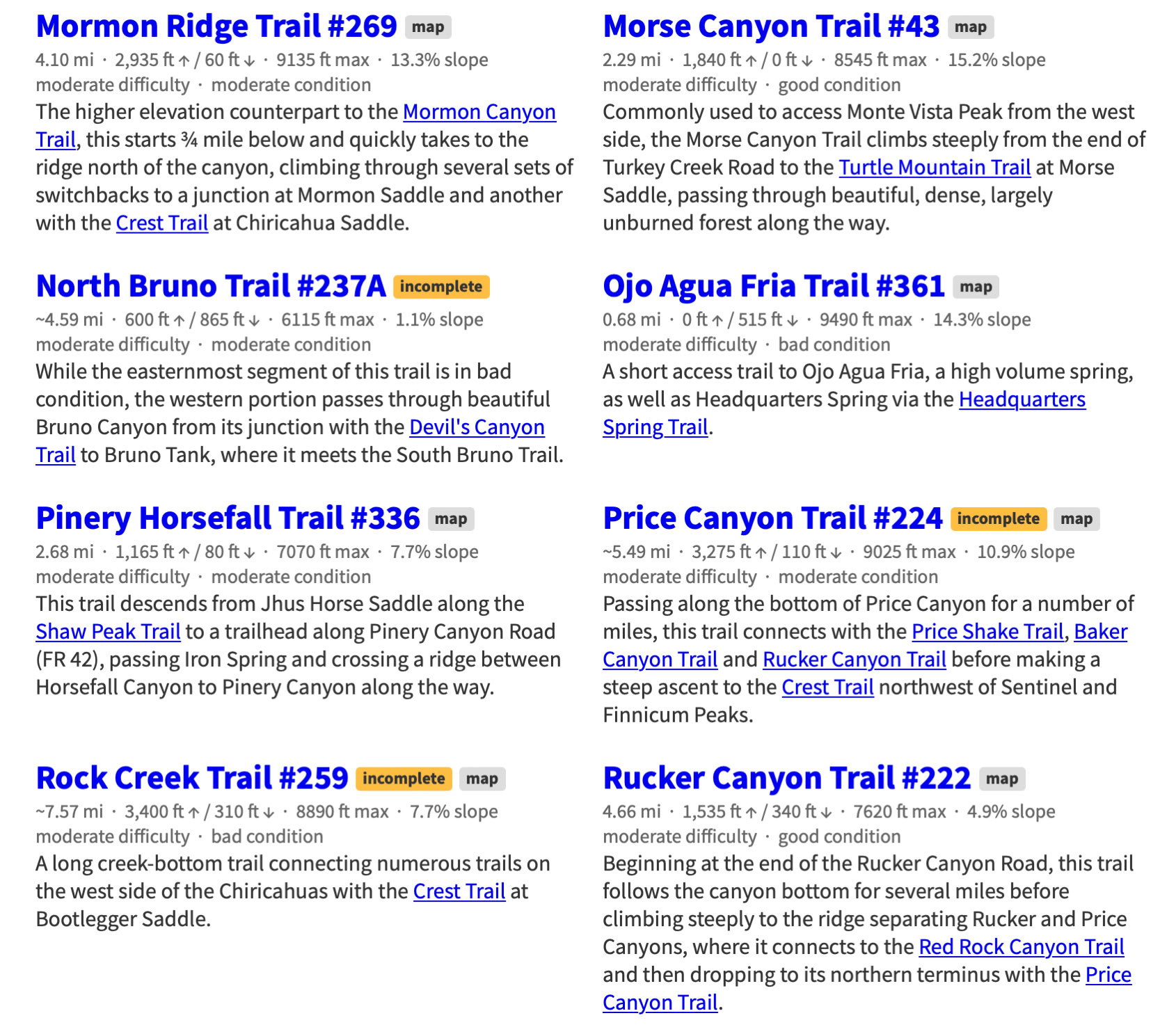
Chiricahua Mountain Hiking Trails
This project -a Herculean task - was started by Jonathan Patt as a collection of GPS data recorded while hiking in the Chiricahua Mountains of Southeastern Arizona starting in 2012 and expanded slowly into this site over a six month period beginning around 2013, during which it became obvious that much of the existing Chiricahua hiking information is out of date and, for some trails, nonexistent. This site is an attempt to resolve that problem.
If you would like to see a map of these trails or want more information about the project visit the Chiricahua Mountains Hiking Trails web site at:
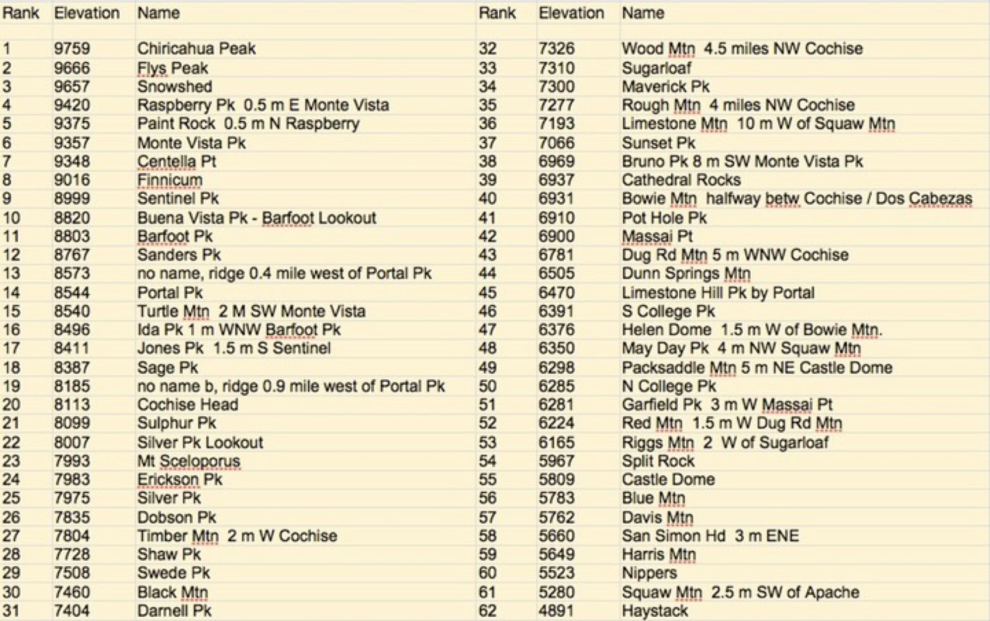
The 62 Highest Peaks, Mountains, Hills, And Lookouts In The Chiricahuas
(Tabulated by Ray Brooks)
(Form Necessary To Work With Trail Crew)
Download - Complete - Mail
To volunteer with the US Forest Service, fill out an application. If accepted, a Volunteer Service Agreement specifying the task(s) will be sent to you.
DOWNLOAD THE FORM. Print it, fill out, sign in block 23, and date. You can scan a signed document and e-mail it toArmando Arvizu at: armando.arvizu@usda.gov
You can also mail the form to Armando at the Douglas Ranger District Office:
1192 W. Saddle View Rd. Douglas, AZ 85607
People can join the list automatically by sending an email to portal-rodeo-hiking+subscribe@googlegroups.com and they should start receiving messages.